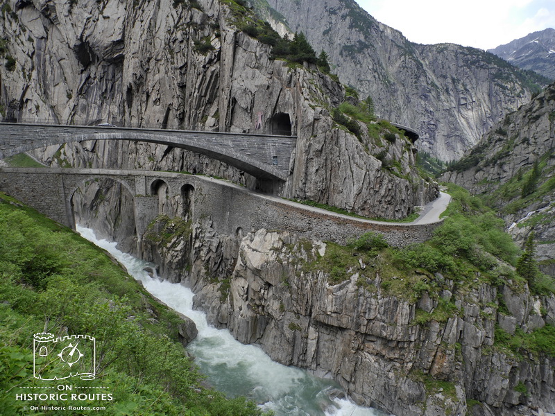
Göschenen is a small village in the Reuss Valley of central Switzerland. Here, at a height of 1,100 m, the Gotthard railway line and the Gotthard motorway disappear into their tunnels. They take with them most of the traffic. The old Gotthard road heads now into an imposing narrow gorge that it somehow needs to navigate.
Series of hairpin turns alternate with snow galleries and short tunnels on the next five kilometers. The views are impressive: steep walls of bare rock rise for hundreds of meters and the Reuss river roars below. This is Schöllenen Gorge, the key to the St Gotthard route.
Coming out of the last tunnel, the view suddenly opens up. A wide valley with green pasture all around and the scenic village of Andermatt is right in front.
Taken in by the views of Schöllenen Gorge and the challenging drive up the winding road it is easy to miss the best part.
Between the two tunnels at the upper end of the gorge, just before reaching Andermatt, there is a small car park. The modern road bridge crosses the river here and disappears into a tunnel. Just below – hidden from view – lies Devil’s Bridge.

Devil’s Bridge
The St Gotthard route was a latecomer to the big crossings of the Alps. Despite its central location and connections to the river systems of the Rhine in the North and the Po in the South it was not used until the early 13th century.
The reason for this was the very location that now is Devil’s Bridge.
For centuries it was not possible to build a passage across the vertical cliffs of Schöllenen Gorge and to throw a bridge across the Reuss.
Only in the 1220s an attempt was successful. A boardwalk was constructed outside the cliff south of today’s bridge. Wooden beams were wedged into both sides of the river and the walkway built for some 60 meters supported by the beams. To cross the Reuss, a wooden bridge was built where today’s bridge stands. Legend has it that the devil had his hand in the construction because it was so daring for the time.
This combination of a boardwalk alongside the cliff and the bridge across the Reuss allowed pack animals to navigate the upper Schöllenen Gorge and thus opened the whole St Gotthard route.

Later history
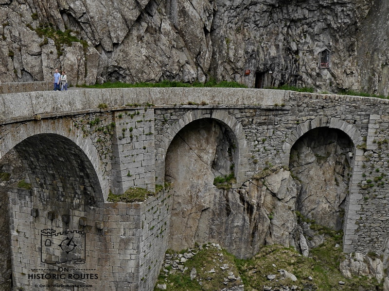
The wooden bridge was replaced after almost four centuries by a stone structure in 1595. The foundations of that bridge can be seen today on the northern side of the Reuss next to the current bridge.
After five centuries, the wooden boardwalk was destroyed in 1707 and replaced by a tunnel through the cliff. This tunnel – the Urnerloch – was the first road tunnel in the Alps. Originally, only wide and high enough for pack animals it was widened several times. Today it is the last tunnel before reaching Andermatt on the modern road.
During the Wars of the French Revolution, the forbidding Schöllenen Gorge was the site of a major battle between French and Russian troops in 1799. This left Devil’s Brigde badly damaged and the St Gotthard route impassable for 30 years. Only in 1830 was the current bridge constructed, wide enough for horse drawn carriages.
The modern road with the road bridge and tunnels was constructed in the 1950s. Until then cars had to drive on the old single lane road that today is the walking path.
Even the road construction of the 1950s could not keep up with the increased traffic. But with the Gotthard road tunnel opened in 1980, transit traffic stopped in the Schöllenen Gorge.

Visit Devil’s Bridge today
Stepping away from the car park and down toward Devil’s Bridge takes you away from modern traffic with all its engineering feats. The roaring river blankets the sound of cars on the bridge above.
The walking path hairpins around the cafe and opens up views of the cliff on the other side of the river. Passing below the modern road again, Devil’s Bridge comes into view with the delicate arch spanning the river. The roaring of the Reuss is now more intense as it hammers against the cliffs just below the bridge.
On the opposite side the path is almost glued to the cliff side, hanging above the river half way from the top of the sheer rock.
The scenery is impressive today and you start to get an idea why people centuries ago felt a supernatural hand in all of this.
While Devil’s Bridge still exists and can give us a glimpse into the past, the boardwalk on the cliff-side and its successor, the early Urnerloch tunnel have been gobbled up by modern engineering a few hundred meters away towards Andermatt.
Standing near Devil’s Bridge above the river maybe gives you an idea about the old wooden boardwalk. That boardwalk would have been narrower and less secure but the roaring Reuss river is still intimidating today.
On the cliff near the bridge is a small entrance into the rock however that gives you an idea about the Urnerloch: The tunnel inside the cliff leads upriver for less than 100 meters, about the same distance as the original Urnerloch. It is just wide and high enough for a person to walk through. Unlike the tunnel centuries ago it has electric lighting though. Even in there, the noise of the river hammering the rocks is always present.
The St Gotthard route has probably been the most innovative route through the Alps for centuries. The 19th century’s mountain railway, the motorway tunnel completed in 1980 and the 57 km long, 21st century base tunnel are impressive achievements.
Their spiritual predecessor however stands in the Schöllenen Gorge from a time where a narrow bridge, a tunnel to walk a donkey through and a walking path on the cliff’s edge were enough for a major mountain crossing.
Human ingenuity – probably more than the Devil himself – were the driving force to build a route through this remote mountain landscape 800 years ago.
If you want to see more of the Schöllenen Gorge, go for a 5 km walk.
There is a signposted route between the Andermatt and Göschenen railway stations. You can walk either and take the train back.
– Railway information – Matterhorn-Gotthard Railway – link

Hugh o Neil Earl of Tyrone lost a pack horse here when it fell into the gorge on 17 March 1608 and the sum of £200 , ironically st Patrick’s day, on route to to Rome , ( flight of the earls sept.4 1607)
Hi Micheal,
Thanks for sharing that interesting piece of history.
I found this website that gives an overview of the flight and some more shared Irish-Swiss history:
https://www.swissinfo.ch/eng/when-irish-history-met-swiss-hospitality/6506176
Regards
Jens