The Hellweg is the most famous road in Westphalia. This historic region of Germany stretches from the Rhine to the Weser rivers. Following the Westphalian Hellweg today is a journey back in time more than 1,000 years when Charlemagne built this road.
The Ruhr Area
I was curios how much of the old Westphalian Hellweg can be found today and decided to explore the first stretch by bike. Starting in Duisburg and going to Dortmund through the Ruhr area would be a nice day trip.
The Ruhr is one of the key areas of 19th century industrialization in Germany.
Iron and coal mining, steel production and related industries led to a population boom in the 50 km stretch between the Rhine River and Dortmund.
The growing cities, industries, new roads and railways changed the pre-industrial landscape almost beyond recognition. How much of the Hellweg can remain here?

Duisburg is where the Ruhr river joins the Rhine. The city is still a trading and logistics hub with its big inland port, just as in the Middle Ages.
The old city center on the inner harbor is where the Romans held a bridgehead and where later the city started to form around a castle. This historic core however can easily be overlooked in a city that is dominated by the largest inland port in Europe, steelworks and seemingly endless residential zones.
The Hellweg route led to Mülheim, where the Ruhr River was crossed. Today’s Mülheimer Strasse is following that route. It is lined with shop fronts and residential buildings for most of the way and has a tram line connecting the two cities.
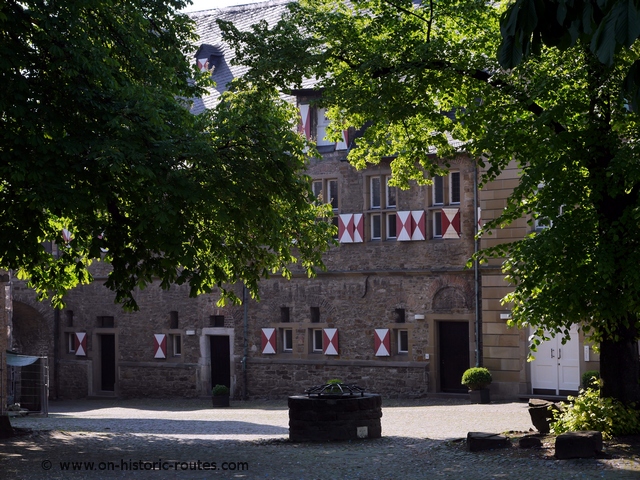
Shortly before Mülheim is reached, there is an interesting building on the left side of the road. Castle Broich was built in the 9th century to guard the ford across the Ruhr and the river against Viking raids.
A brief history of the Hellweg
The Ruhr river was the only natural obstacle on the Westphalian Hellweg. It uses the high land at the south end of the north German plain and at the north end of the hilly and forested Sauerland hills. It it an open countryside, which is relatively dry with no waterways to cross. This made travel easy in a land where marches and thick forests were plentiful.
Charlemagne used the Hellweg in his campaigns against the Saxons in what today is Westphalia. Communities like Bochum or Paderborn were founded as imperial courts around 770 AD and grew into cities. There were small stations every 15 to 20 km along the way to support travelers. These are today’s communities along the way, which are highlighted on the map.
In the Ruhr area, the cities of Essen, Bochum and Dortmund grew from estates dating back to the time of Charlemagne and their city centers are linked by the old route.
Finding traces of the Hellweg
Today, Castle Broich was one of the last hints of the old route. All the way to Essen modern freeways and railway lines along with a patchwork of industrial and residential zones have changed the area to where no trace of the Hellweg remains.
It was only when I reached the small gap in the otherwise continuous urban area between Essen and Bochum traces began to appear again.
Here and all the way to the open plain around Soest, street names carry the name ‘Hellweg’. ‘Wattenscheider Hellweg’ or ‘Harpener Hellweg’ named after the respective suburb link together to form the Westphalian Hellweg through the neighborhoods of Bochum, Dortmund and Unna. This is a unique feature and shows that the heritage of this old route is still relevant today. The landscape seemed changed to a lesser extent here. Few more open areas like gardens, parks and field appear and are alternate with classical heavy industry and commercial zones.
The Westphalian Hellweg formed the main street in many of the historic towns along the route. Nowhere, however is it clearer to see as in Dortmund:
The main pedestrian zone is not only named after the Hellweg, it is the former East-West street of the city. In Dortmund, the Hellweg met with a route from Cologne to Münster and Bremen making the city an important trade center. Consequently, Dortmund was the most important hanseatic city in Westphalia. The Reinholdi church of Dortmund is built, where these two routes meet.

The Westphalian Plain
For the second part of my trip along the Westphalian Hellweg, I went by car from Dortmund to Corvey Abbey on the Weser river. It felt like a different trip altogether, not just because of the transportation: Just after leaving Unna, after about 70 km of continuous urbanized area of the Ruhr area, fields of wheat, canola and corn appear. It was quite a contrast to the metropolitan Ruhr area.
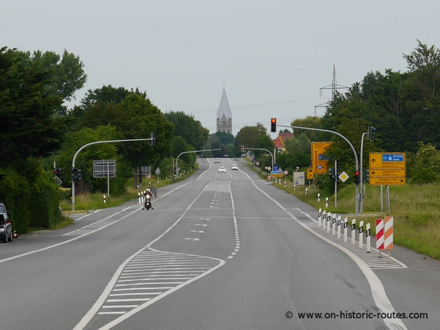
Even with cities like Soest and Paderborn on the way have 50,000 and 150,000 people as well, the Westphalian plain has a more rural setting than the Ruhr area. It is an open agricultural landscape, where you can often see the bell tower of the next town’s church some 10 km away.
The route was know following the 19th century paved road, built by the Prussians. Today it is the federal road 1 (B1), which runs within a few hundred meters of the old Hellweg.
Towns along the way, like Werl or Soest have been members of the Hanseatic League and participated in trade along the Hellweg, especially with salt. This was manufactured here for centuries.
The open plain continues for about 70 km up to Paderborn. Charlemagne built a royal palace here in 776 during his Saxon wars and made the town a bishops seat. This soon became a prince-bishopric, which lasted until 1802.

From Paderborn to Corvey Abbey the character of the Westphalian Hellweg changed again.
Eastern Westphalia is a more forested and hilly area with small villages and towns. Brakel and Höxter are small former Hanseatic towns on the way before the Weser River is reached at Corvey Abbey.
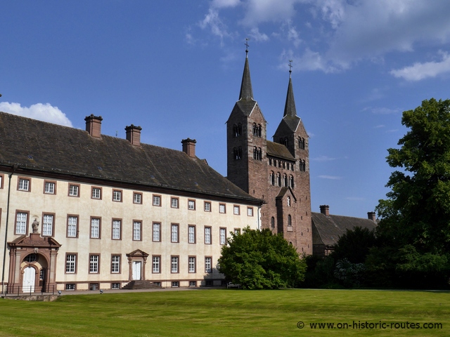
Corvey Abbey
The abbey of Corvey is generally regarded as the end point of the Hellweg.
It was founded by Charlemagne following the Saxon conquest to convert them to Christians.
It was often visited by the royal court and became one of the influential abbeys in the Empire.
In 2014 the Abbey of Corvey was listed as UNESCO World Heritage due to its early medieval architecture of the Western Portal or Westwork. It’s wealth and importance during those times came from the location on the Hellweg.
It was the main transportation line from the Rhine area with cities like Aachen or Cologne and the area around the Harz Mountains in the East, which became an important center of power.
The Abbey of Corvey also was a center for missionary activities in Northern Europe due to its location on the Weser River.
The Westphalian Hellweg Today
The Westphalian Hellweg is one of the oldest roads in the part of Germany that was not under Roman control. It is still visible today and even used for the B1 road.
‘Hellweg’ is a household name in large part of Westphalia and a number of streets carry that name.
In the Ruhr area this is sometimes the only trace of the route as the impact of the industrial revolution changed the landscape drastically.
A trip along the route is worthwhile as it shows not only a variety of landscapes (both natural and man-made) but also the history of Germany from the early middle ages to the 20th century.
Then sign up for our free email newsletter to get all our new posts right to your inbox.
Hallo Jens,
Vielen Dank für den schönen und informativen Bericht über den Hellweg!
Meine Studie zeigt dass der Hellweg ein gesamteuropäisches Projekt gewesen ist.
Die Dokumentation steht in einer Blogseite zur Verfügung:
http://thehellweghistory.blogspot.de/2016/02/scribd-portal-fur-mycelium-of-european.html
Würde mich freuen dein Urteil über diese Thesen zu erfahren.
Schöne Grüsse,
JWR.